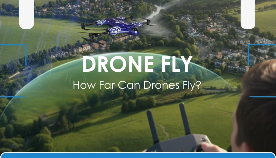
Drones have transformed from simple hobby gadgets into advanced tools for photography, mapping, and industrial inspections. One of the most common questions people ask is: how far can drones really fly? The answer depends on several factors, including drone type, battery capacity, signal strength, and environmental conditions.
Consumer drones typically have a range of 2–10 kilometers, which is more than enough for casual use and aerial photography. Professional and enterprise-grade drones, however, can travel much farther — some exceeding 15 kilometers — making them ideal for agriculture, surveying, and long-range inspections. These distances are also influenced by terrain, weather, and interference.
It’s important to note that legal limits matter just as much as technical capabilities. Aviation authorities like the FAA require drones to remain within the operator’s visual line of sight in most regions. So, while drones can fly far, regulations often keep them closer to home.
Whether you’re a beginner or aiming for long-distance flying, this guide is your roadmap to the skies.
How Far a Drone Can Fly From The Controller?
How far a drone can fly from its controller depends on the type of drone, signal strength, and regulations. Most consumer drones can fly between 2 to 10 kilometers (1–6 miles) away when conditions are clear and interference is minimal. Professional drones may reach beyond 15 kilometers, making them ideal for agriculture, mapping, and industrial use.
However, in many regions, aviation rules like the FAA’s require drones to stay within the pilot’s visual line of sight (VLOS), regardless of their technical range. Obstacles such as buildings, trees, or radio interference can also shorten the effective distance.
In short, while modern drones can technically fly miles from the controller, practical limits like battery life, safety, and legal restrictions usually keep them much closer.
What Determines Drone Flight Range?
Knowing how far a drone can fly is exciting, but it’s only part of the picture. Many hidden factors quietly shape how far your drone can actually go.
Understanding these elements lets you plan smarter flights and get the most from every battery charge.
Here are the most important ones:
Battery Capacity and Flight Time
A drone’s battery is its main source of power. Larger batteries let drones stay in the air longer, while smaller ones run out quickly.
Battery health also matters because old or poorly maintained batteries drain faster. Cold weather can further reduce battery life, limiting how far a drone can travel.
Drone Weight and Design
Weight influences how much energy a drone consumes. Heavier drones deplete batteries faster, lowering flight range, but lighter drones can travel further on a single charge. Aerodynamic designs also help because they don’t have to fight as much air resistance and glide more smoothly, saving energy.
Remote Controller Signal Strength
Battery life determines flight time, but signal strength determines how far a drone can go. Weak signals fade as the drone moves away, which can cause disconnections.
A strong and stable signal keeps the drone connected, and correctly positioning the controller’s antennas can improve range.
Transmission Technology
Not all drones use the same communication systems, which affects their maximum distance. Entry-level drones often rely on Wi-Fi, which works well for short flights but struggles at longer ranges. Advanced drones use systems like OcuSync or Lightbridge, which send clear signals over miles and can switch frequencies to avoid interference, keeping the connection stable.
Environmental Conditions
Even the best drones can have their range limited by the environment. Strong winds drain batteries faster and reduce flight time, while rain, snow, or high humidity can weaken signals and damage electronics.
Cold temperatures can also slow battery performance and reduce range. Obstacles such as trees, buildings, hills, and dense vegetation can block signals and cause disconnections, and urban interference can further disrupt communication.
The table below highlights the main environmental factors that can affect your drone’s flight range, their impact on performance, and the level of influence they have:
Environmental Factors Guide Summary
| Environmental Factor | Effect on Range | Impact Level |
|---|---|---|
| Strong Wind | Drains battery faster, reduces flight time | High |
| Rain / Moisture | Weakens signal, risks hardware damage | High |
| Cold Temperatures | Slows battery performance, reduces range | Medium |
| Obstacles (trees/buildings) | Blocks signal, causes disconnections | High |
| High Interference (urban areas) | Disrupts signal transmission | Medium |
Flying in calm, open areas on clear days gives your drone the best chance to reach its maximum distance safely.
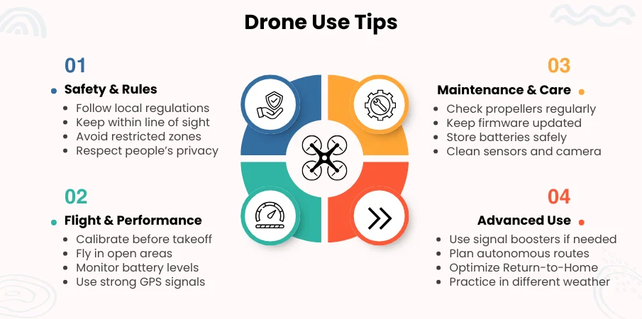
Essential Drone Use Tips for Safe, Smart Flying
Explore essential drone use tips for safe flying. Read article to improve performance and safety.
Comparison Table of Drone Flying Range
Many factors affect how far drones may fly, such as their kind, how they send signals, where they are, and the rules in that area.
The tables below show each of these parts in detail. You will learn how different types of drones compare against each other, what affects their range, and what guidelines you need to follow before flying over long distances.
Transmission System vs Range
The technology that carries signals between your drone and its controller is just as important as its battery. Stronger transmission systems mean longer and more stable flights.
| Transmission System | Typical Maximum Range | Used By |
|---|---|---|
| Wi-Fi | 300–1000 feet | Toy and beginner drones |
| Enhanced Wi-Fi | 0.5–2 miles | Mid-range consumer drones |
| OcuSync (2.0–4.0) | 6–12+ miles | ZenaDrone 1000 and other pro drones |
| Lightbridge | 5–7 miles | Older DJI professional drones |
| Autel SkyLink | 7–9 miles | Autel EVO series |
| Advanced Custom Links | 15+ miles | Industrial and enterprise drones |
Choosing a drone with a powerful signal system can dramatically extend your flying range while reducing dropouts or lost connections.
Legal / Regulatory Limits in the US
Even if your drone can fly for miles, the drone law might not let you. Knowing the rules helps you fly far while staying compliant.
| Regulation | Limit on Distance | Purpose |
|---|---|---|
| Line of Sight Rule (Part 107) | Must keep drone within visual line of sight | Prevents collisions, maintains control |
| Maximum Altitude Rule | 400 feet AGL (Above Ground Level) | Keeps drones clear of manned aircraft |
| BVLOS (Beyond Visual Line of Sight) | Requires FAA waiver | For advanced commercial operations |
Always check your local drone flying regulation before pushing for long distances, especially if you plan to fly beyond visual line of sight.
Types of Drones and Their Flight Ranges
There are many different types of drones, and the distance they can fly depends on what they are made for and how they are made.
Some are meant for easy indoor entertainment, while others are made to go a long way to accomplish tasks like mapping, accomplishing delivery, or even doing military operations.
Here is a list of different kinds of drones, their normal flight range, and their usual uses.
1. Toy Drones
Toy drones are the smallest and most basic type. They are portable, simple to control, and suitable for beginners and younger users. However, their range is limited because of their small batteries and small transmitters.
- Typical range: 30–300 feet
- Best for: Practicing basic flying skills, indoor play, and short backyard flights.
2. Mini Drones
Mini drones are small and light, making them easy to carry and fly everywhere. However, their small size limits battery capacity and signal strength, so they are best suited for quick, simple flights.
- Typical range: 0.2–1.5 miles
- Best for: Indoor flights, short outdoor flights, and casual fun.
3. Consumer / Recreational Drones
Consumer drones are made for hobbyists, travelers, and content creators. They offer stronger signal connections, better cameras, and longer battery life than toy drones, making them perfect for capturing photos and videos from a distance.
- Typical flight range: 0.5–7 miles
- Popular model: Zenadrone 1000
4. FPV Drones
FPV (first-person view) drones are known for their speed and maneuverability. Pilots can see in real time using onboard cameras, creating the impression that they are flying from within the drone.
Typical flight range: 0.5–3 miles
Best for: Racing, freestyle tricks, and immersive flying experiences.
5. Delivery Drones
Delivery drones are built to carry small packages over medium distances with long-distance heavy load drones. They have strong motors and intelligent navigation systems to safely reach their destinations while avoiding obstacles.
- Typical flight range: 5–10 miles
- Best for: Delivering parcels, food, and medical supplies in local areas.
6. Professional / Commercial Drones
Professional and commercial drones are designed for serious work. They have high-end cameras, powerful motors, and advanced flight systems that allow them to cover large areas, making them ideal for drone flight range for farming and aerial property inspection .
- Typical flight range: 5–15+ miles
- Common uses: Mapping, aerial photography, monitoring crops, inspecting buildings, infrastructure, and drone-based environmental assessment.
7. Military Drones
Military drones are highly advanced aircraft built for long-range and high-altitude operations. They have secure communication systems, heavy-duty power sources, and specialized sensors to complete missions lasting hours or days.
- Typical flight range: 100+ miles
- Best for: Reconnaissance, surveillance, defense operations, and strategic missions.
Drone Flight Range Summary Table
| Drone Type | Typical Flight Range | Typical Flight Time | Common Use Cases |
|---|---|---|---|
| Toy Drones | 30–300 feet | 5–10 mins | Indoor flying, kids, beginners |
| Mini Drones | 0.2–1.5 miles | 5–10 mins | Indoor & short outdoor flights, casual fun |
| Recreational / Consumer Drones | 0.5–7 miles | 15–25 mins | Hobby flying, travel, content creation |
| FPV Drones | 0.5–3 miles | 10–20 mins | Racing, freestyle tricks, immersive experiences |
| Delivery Drones | 5–10 miles | 20–30 mins | Local deliveries, medical supplies |
| Professional / Commercial Drones | 5–15+ miles | 30–60+ mins | Mapping, inspections, filmmaking |
| Military Drones | 100+ miles | Hours – Days | Reconnaissance, surveillance, defense missions |
Knowing a drone’s range helps you choose the right one for indoor fun or professional use. Consider flight distance, battery life and local rules to make the most of every flight. This way you can fly safely and confidently every time.
How Far Can Popular Drones Fly?
Here’s a quick overview of different drones, showing how far they can fly, how long they last, and the systems that keep them connected during flight.
| Drone Model | Maximum Range | Maximum Flight Time | Transmission System |
|---|---|---|---|
| ZenaDrone 1000 | 15+ miles | 40+ mins | Advanced OcuSync |
| DJI Mini 4 Pro | 12 miles | 34 mins | OcuSync 4.0 |
| DJI Air 3 | 12 miles | 46 mins | OcuSync 4.0 |
| Autel EVO II Pro | 9 miles | 40 mins | Autel SkyLink |
| Skydio 2+ | 6 miles | 27 mins | Skydio Beacon Link |
| Parrot Anafi USA | 4 miles | 32 mins | SkyController 4 |
| Holy Stone HS720E | 2.5 miles | 23 mins | Enhanced 5GHz Signal |
This comparison helps you see how modern drones perform in terms of distance and flight time, so you can choose one that fits your needs, whether for fun flights, creative projects, or professional work.
Legal and Regulatory Limits for Drone Flights
Before testing how far your drone can fly, it’s important to understand the legal and regulatory limits that guide your flights. These rules are designed to keep you, others, and the skies safe so you can fly with confidence instead of worrying about accidents or fines.
Line of Sight (LOS) Regulations
The line of sight (LOS) rule means you must always see your drone with your own eyes while it’s flying. This keeps you in control, helps you avoid obstacles, and lets you react quickly in emergencies. If you can’t see your drone, it’s already gone too far.
FAA and EASA Rules
The Federal Aviation Administration (FAA) sets drone safety limits in the United States, while the European Union Aviation Safety Agency (EASA) enforces similar rules in Europe.
To ensure safety, drones must stay within your line of sight and usually below 400 feet high. Also, flying near airports, emergency zones, or restricted airspace is prohibited.
BVLOS (Beyond Visual Line of Sight) Flights
Beyond visual line of sight (BVLOS) flights let drones fly farther than you can see, but they require special approval. These flights are mainly for professional work like land surveys, deliveries, or testing the longest drone flight time. They also need advanced safety systems like sensors and automatic return-to-home features.
Drone Range Restrictions in Different Countries
Drone laws vary from country to country. Some allow drones to fly long distances, while others limit them to just a few hundred meters. Always check local rules before flying because legal limits often matter more than your drone’s battery or speed.
How to Extend Your Drone’s Flight Range Safely
Want your drone to fly farther without worry? You can make that happen by following a few smart and safe steps.
- Use Stronger Antennas/Boosters – Improve signal strength for longer range.
- Add High-Capacity Batteries – Extend flight time with more power.
- Pick Wide, Open Spaces – Avoid obstacles that block signals.
- Adjust Drone Settings – Optimize Return-to-Home, transmission, and flight modes.
- Follow Local Laws – Stay safe and compliant while flying.
You can explore further with the proper setup and smart flying while keeping every flight safe.
Applications of Long-Range Drones
Long-range drones are changing how we work, explore, and respond to challenges. Their ability to fly far and stay in the air longer lets them reach places that are difficult or risky for people. Here’s where they make a real difference:
Aerial Photography
They capture wide, detailed views from above, making them ideal for films, real estate, tourism, and live events.
Surveying and Mapping
Advanced models like the ZenaDrone 1000 quickly scan large areas, collect precise data, and perform power line monitoring. In addition, these drones also track land changes for construction, mining, and Using Drones for Property Surveys.
Agriculture
They help farmers monitor crops across vast fields using agricultural drone technology, spotting pests, drought, or plant stress early to guide faster action and smarter planning.
Search and Rescue
They reach forests, mountains, or disaster zones fast and can carry radios, first-aid kits, or water to people until rescue teams arrive.
Delivery
They are being tested to deliver packages, food, or medical supplies to remote or hard-to-reach locations.
Long-range drones open up new possibilities by making distant places easier and safer to reach.
Future of Drone Flight Range
Drone technology is advancing fast, and one of the most significant leaps ahead will be how far they can fly. As new innovations roll out, drones will go farther, last longer, and fly smarter than ever before.
Smarter Batteries
New battery tech will let drones fly farther and stay in the air longer without adding extra weight, making long missions easier and more reliable.
Stronger Connections
With fast 5G networks and steady satellite links, drones will stay connected over long distances, giving pilots clearer control and safer flights.
AI-Powered Flights
Artificial intelligence will help drones fly beyond visual line of sight on their own, avoiding obstacles and adjusting routes to make long-range flights safer and smoother.
With these breakthroughs on the horizon, the future of drone flight range looks limitless. Soon, reaching distant places will be as simple as lifting off.
Conclusion
Drones can fly surprisingly far. Some can travel just across your backyard while others can cover miles in the distance, but how far they go depends on much more than just battery size.
Every factor shapes their true range, from their design, weight, and signal systems to environmental conditions and legal rules. By understanding these limits and following safe practices, you can unlock your drone’s full potential without risking damage or breaking regulations.
As drone technology keeps improving with smarter batteries, stronger connections, and better safety systems, the distances they can reach will only grow.
Plan wisely, fly safely, and enjoy the incredible freedom of seeing the world from above, one flight at a time.
Frequently Asked Questions
What is the Average Range of a Drone?
Most consumer drones can fly between 0.5 to 7 miles, depending on battery life, signal strength, and environmental conditions. Flight distance varies widely by model.
Which Drone Has the Longest Range?
High-end drones built for industrial or professional use offer the longest ranges. Models like the ZenaDrone 1000 can cover several miles safely, ideal for long-distance inspections.
How Far Can a ZenaDrone 1000 Fly?
The ZenaDrone 1000 is built for professional long-distance flights and can cover several miles per charge. Its stable signal and durable battery make it ideal for inspections and surveying.
What Happens When a Drone Flies Out of Range?
When a drone moves beyond its controller’s range, it may hover, return home automatically, or land depending on its fail-safe settings, preventing crashes or lost devices.
How long can drones stay flying?
Flight time depends on the drone. Small drones usually last 20–30 minutes, while advanced drones can stay in the air for over two hours under ideal conditions.
Can you fly a drone out of sight (BVLOS)?
Yes, but is it only allowed with special permission and advanced drones. Most recreational drones must stay within your line of sight.
How high can a drone fly?
Most consumer drones are legally limited to 400 feet above ground level. Professional drones with permits can fly higher for inspections or surveys.
Can drones fly in strong winds?
Drones can operate in moderate winds, but strong gusts reduce stability and battery efficiency. High-end drones are designed to handle higher wind speeds safely.
Can you extend a drone’s flight range?
Flight range can be extended by using advanced transmission systems, high-capacity batteries, flying in open areas, or upgrading to drones designed for long distances.
Can drones be used in bad weather?
Flying in rain, snow, or extreme conditions is generally not recommended, as moisture can damage electronics and reduce battery performance.
How far can drones fly legally?
Drones must typically remain within visual line of sight unless special permission is granted. Legal limits vary but often range from a few hundred meters to several miles.
How Far Can You Fly a Drone Near an Airport?
Drones are generally restricted within 5 miles of airports without authorization to avoid interference with manned aircraft.